 Google Maps is one of the most useful products ever released by the tech guys at Google and it’s a sentiment shared by a lot of people who rely on this product for various navigation purposes. It’s a great thing that the guys who manage Maps are not resting on their laurels and are continuously developing this very wonderful service.
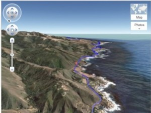
The newest addition to the Google Maps service is a 3D bird’s eye view of the map that shows the route that you want to navigate. This is a nifty new perspective, which is also called a 3D helicopter view, that makes navigation easier and more fun. To use this new feature all you need to do is to identify your starting point and your end point at the directions section. Google Maps will now calculate the proposed route. By clicking on the 3D button that is located next to the text that reads “driving directionsâ€, the view will shift to the Google Earth view and you can now navigate the route given to you by Google Maps.
Users have a fairly good level of control over the feature. They can pause the 3D simulation at any time and also rotate the map so they can explore the surrounding areas around the route. They can also view every leg of the trip after resuming the simulation. They can do this by watching one section on the left side of the screen. Clicking on specific sections will allow them to jump to other sections. The 3D mode can also be reverted back to 2D mode at any point in time.
The 3D helicopter view will be gradually rolled out to different regions so if you don’t immediately see it in your neck of the woods just wait and you’ll see it eventually.
Originally posted on October 3, 2011 @ 2:20 pm