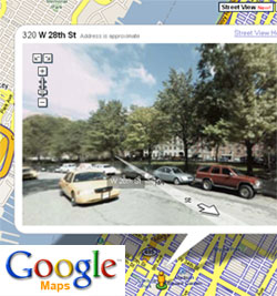
 Google Inc launches this morning at the Where 2.0 conference in San Jose the latest additions to the Google Maps: the Street View and the Mapplets. With these new mapping innovations, users can now enjoy navigating within 360 degree street-level views of different cities in the US, while developers are provided new geographic resources to create mini mapping applications with.
Street View allows users to virtually walk through streets, buildings, restaurants, parks, as well as pedestrian lanes, and bus stops and street signs with rich panoramic imagery. Initially available street-level maps are of San Francisco Bay Area, New York, Las Vegas, Denver and Miami, with the promise of expansion to other cities of the state. (The image above is of W 28th St, some blocks away from Madison Square Garden.)
Mapplets, on the other hand, is the new toy for developers as it allows them to create mini applications for Google Maps by manipulating codes and javascript to meet the geographic content requirement of a specific website (just like how, for example, Google Gadgets is used with iGoogle). “Embedded mashups” as it is called, the Mapplets technology makes mapping applications easy for developers with information varying from housing listings to crime data to distance measurements.
Try and test the latest from Google Maps here.
Originally posted on May 29, 2007 @ 9:06 pm
Here are some cool sightings:
ttp:\\www.laudontech.com\StreetView\streetview.html
Thanks for this site!
hifue.info